
Topographic Mapping
Contours and surface, drawn from measured ground.
Your design needs existing grade, and the site is bigger, rougher, or busier than a ground crew can cover economically.
What you get back is a drawing your engineers can design against on day one, not a dataset someone has to turn into one first. We can capture the site ourselves, or start from data you already have.
One capture serves the whole design effort. The civil engineer designs against measured grade. The estimator takes quantities off a real surface. The surveyor has a dense dataset to check against. The reviewing municipality sees existing conditions documented rather than assumed.
What We Can Tell You
What the capture lets us report, measured rather than estimated.
Grade And Contour
Existing grade at any point or along any line
Contours at the interval your drawings use
Drainage And Volume
Slopes and drainage direction across the surface
Where water collects and where it leaves the site
Volume of material in any defined area
Features And Change
Position of visible site features relative to the terrain
Elevation difference between any two captures of the same site
How It Works
Every capture is tied to ground control. There is no version of this work without it, because control is what lets us state an accuracy rather than estimate one. We establish and document highly accurate control ourselves. Where the deliverable has to carry survey-grade accuracy, that control is set and certified by a licensed surveyor. If your team already has one on the project, their control is what we work from. If not, we bring one in and it is priced as an addition.
Control first, every time
When we are doing the capture, open ground maps well photogrammetrically and wooded ground needs LiDAR to reach the surface at all. We pick based on cover, access, and the accuracy your design requires, and we tell you which we used and why.
Method chosen by site, not by habit
Pavement edges, curb lines, swales, ditch bottoms, and the top and toe of every slope are picked up and enforced in the surface. This is the step that makes a model behave like real ground, and it is done by a person looking at the data.
Breaklines and surface review
Independent measurements taken on the ground confirm the surface agrees with reality, reported against ASPRS positional accuracy standards. Without them, accuracy is a claim rather than a verified result.
Check shots
Or we start from what you already have
Raw drone imagery we process into a cloud, a point cloud or surface someone else produced, or a control book from your surveyor or civil engineer. If it is something a drafter could start from, we can start from it. Accuracy in that case is inherited from whoever collected the data, and we state that plainly rather than restating it as ours.
We build machine control models for Trimble, Topcon, and Leica systems. Note that a machine control model comes from the proposed design surface rather than from existing conditions, so we need the civil design in hand. The existing surface we capture is what the cut and fill is measured against.
Machine control, where the equipment needs it
Horizontal projection and vertical datum are set from your project before anything is drafted. Most work in this region runs on a state plane coordinate system, but the one that matters is whichever your drawings already use. The most common reason a surface does not line up with a design is that it arrived in a different reference frame than the drawings, or carried ellipsoid heights where the drawings use an orthometric datum. When you supply the data and its system is unknown or does not match, we identify it, transform it, and state the transformation applied.
Coordinate system settled first
The surface, the contours, and the linework are delivered as a working CAD file in the format your team already uses, not as an export someone has to rebuild.
Drafted in your environment
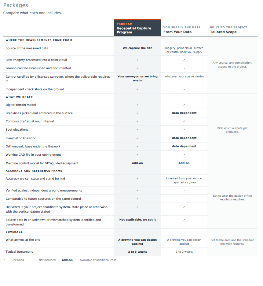
Contours are easy to generate and hard to get right.
Any software will draw contours from a point cloud in a few minutes. Those contours follow parked vehicles, brush piles, tall grass, and stray returns, and they round off the edges that matter most.
A surface behaves like ground only once someone picks the breaklines. Pavement edges, curb lines, swale bottoms, and the top and toe of each slope have to be drawn in deliberately, because those are the lines water follows and the lines a grading plan is built on.
That work happens in our drafting and modeling department either way. The difference between the two columns is not the drawing, it is what sits underneath it. When we capture the site, we set the control, shoot the checks, and can state an accuracy we stand behind. When you supply the data, we produce the same drawing and report the accuracy your source carried, including the case where it carried none.
Why Most Clients Take the Program
The costly part is already paid for
Mobilization, control, access, flight planning, a day the weather cooperates. Those sit in the single service. Every additional data type is captured on the same trip, so the second and third deliverables cost a fraction of the first.
You can’t go back to that day
Conditions change, access comes down, work gets covered. Capturing one data type now and deciding you need another later means paying to mobilize twice.
One control means the data works together
Separate engagements don't register to each other. The program is one dataset, not three files.
The record outlives the report
The report answers today's question. The dataset answers every future one, including comparison, design, renovation, and claims.
Tailored Scope
Tailored Scope starts at the single-service level and goes up. Different coverage, different deliverables, different cadence.
Frequency
Once, at milestones, or on a set cadence.
Extent
Which areas, which elevations, which portion of the site.
Accuracy
Whether survey control and independent verification are required.
Format
Raw data, registered data, or drafted output in your CAD environment.
Combination
Any services from any package, assembled for the project.
Working with Your Team
We work alongside your project team. Engineers, architects, surveyors, contractors, and construction managers all get better information to work from, and nothing we deliver takes the place of what they do.
We measure. Your engineer of record, architect, and surveyor interpret. Our deliverables are built to go straight to the people already responsible for the design and the compliance calls.
The test for anything we write: could someone go up there with a tape and check it? If yes, it is ours. If it requires judgment, it is theirs.
Bring your own engineer, or we can introduce you to one
Most projects already have a structural engineer, envelope consultant, or architect in that seat, and our deliverables are built to land on their desk in a format they can work from the day they get it. When that seat is empty, we can put you in touch with firms we work with regularly who already know how to read what we produce. They engage with you directly and we take no fee or markup on their work. We stay on the measurement and they stay on the interpretation, which is what keeps both of them worth anything.
Limitations of use
Deliverables are aerial and terrestrial measurement products. They are not a boundary survey, not a topographic survey certified by a licensed land surveyor, and are not intended for establishing property lines, easements, or legal descriptions.
Accuracy is stated per deliverable. Where results will be used for design, permitting, regulatory submission, or determination of contractual compliance, they should be reviewed by your licensed surveyor or engineer of record.
Observations are those identified within the area captured, on the date captured, under the conditions recorded. Areas not visible to the capture are listed with each delivery.
DronePoint provides construction progress monitoring for surveyors, engineers, contractors, and property owners across New York, Pennsylvania, Ohio, and New England. Our capture work is processed in-house by Professional Drafting Service, the drafting firm behind DronePoint since 19887 – so what you receive is a finished, usable deliverable rather than a raw data dump you have to hire someone else to clean up.
Deliverables are provided in the formats and coordinate system your project requires.
Tell us about your site and we’ll come back with a scope and a price.
Call 716-447-9698 or request a quote.