Thermal Inspection
Thermal shows you where a surface is behaving differently than the rest of it.
Something is going wrong and nobody can point to where it starts. Heat leaving a building, water getting in through a roof, a buried line losing heat into the ground, a stain on a ceiling with no obvious source, a module in an array that stopped producing. Thermal finds the spot. It does not tell you what is in it.
This page explains how thermal works and what it can and cannot answer. If you already know what you need looked at, the routing at the bottom will send you to the right place.
What a Thermal Survey Tells You
What the capture lets us report, measured rather than estimated.
The Anomaly
Where surface temperature patterns differ from the area around them
Whether each anomaly reads warmer or cooler than its surroundings, and by how much relative to them
Extent And Location
The measured extent of each anomaly, in square feet
The location of each observation by elevation, floor line, and bay
Context And Change
The conditions the survey was flown under, including ambient temperature, wind, cloud cover, solar loading, and the interior to exterior differential
What changed since a previous survey of the same building
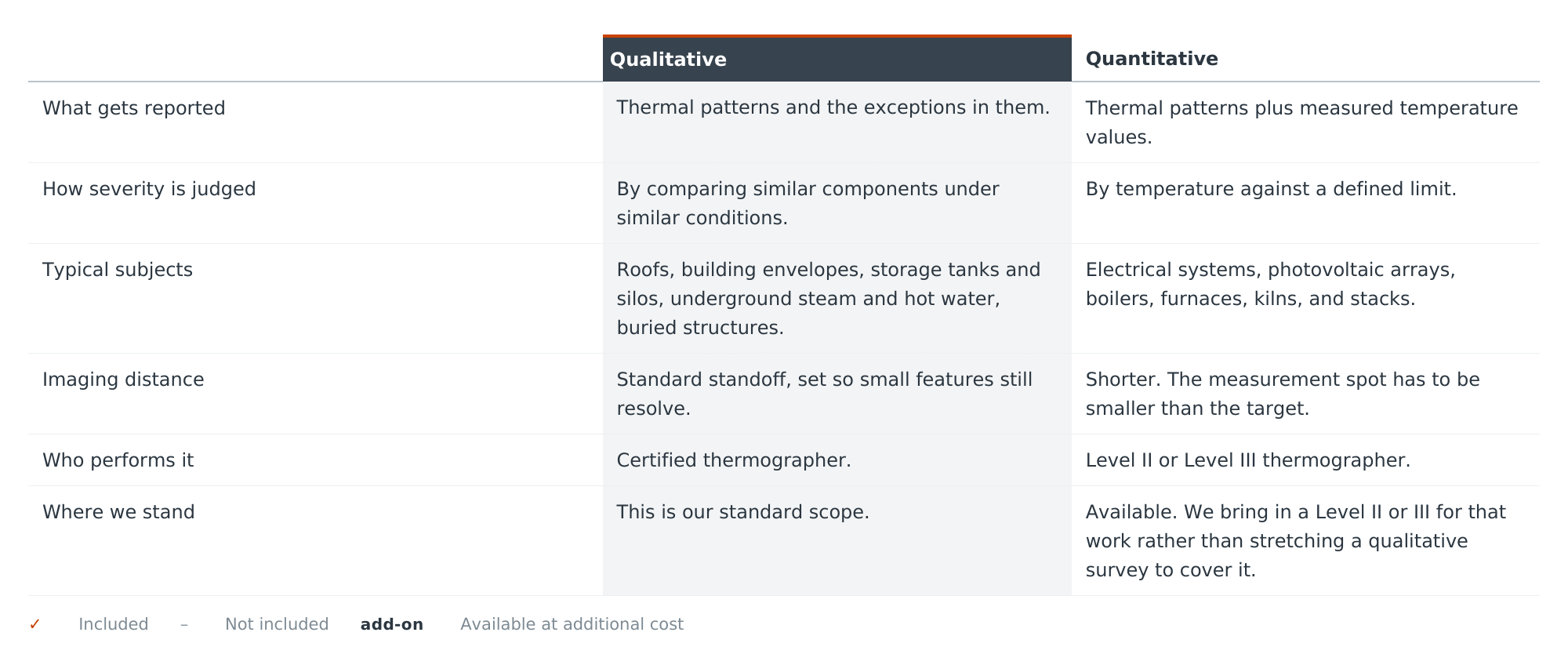
Infrared inspections fall into two categories. Both read thermal patterns. The difference is whether a temperature value gets attached to them, and that difference decides the equipment, the distance, and who has to be holding the camera.
Roofs and building envelopes are qualitative applications by definition in the standards this work follows. That is not a limitation on the survey. It is what the survey is.
Qualitative and Quantitative
How It Works
Capture, review, and reporting follow the practice the certification requires, and the report comes out in the format an envelope engineer expects to receive.
Flown by a certified thermographer
Thermal needs a temperature difference across the surface to show anything. Too little differential and the building reads flat. Rain and heavy wind strip the signal. Overcast skies are often an advantage, because there are no solar reflections to read around. On some surveys solar loading is the thing that creates a usable difference in the first place, so the right window is a judgment about the building rather than a rule. We check the forecast against the structure and schedule accordingly, and we will move a date rather than fly a survey that cannot answer the question.
Conditions decide whether the survey is worth flying
For most envelope work the thermal itself is flown at night, once the building has shed its solar gain and heat loss and trapped moisture read most clearly. The daytime visit is what produces the visible imagery, because a thermal pattern means very little until you can see what is actually in that spot, and nothing photographs in the dark. Some subjects do read well during the day, but as a rule the night pass is the inspection and the day pass is the reference. Plan on the after-hours return as part of the work rather than as an extra.
Every thermal survey in two visits
Thermal reads the surface it can see and nothing behind it. It does not image through trees, vegetation growing on a wall, glass, standing water, or anything else between the camera and the material. Anything the survey could not reach is listed with the delivery rather than left for you to notice.
Line of sight, and what breaks it
Non-contact and non-invasive, by design
Nothing we do touches or opens the building. Confirming what an anomaly actually is usually requires something that does, so we work alongside the trades who can: a roofer taking core samples, a contractor with a moisture meter, building maintenance running the HVAC so the system can be seen under load. We coordinate with them rather than standing in for them.
Each observation is tied to an elevation, a floor line, and a bay, measured for extent, and recorded with the conditions it was captured under.
Located, measured, and reported
What thermal can and cannot tell you
A thermal camera shows how a surface compares to itself. That is what it does. Everything useful about a thermal survey comes from knowing what a difference at a particular spot, under particular conditions, is likely to be caused by.
The same warm patch can be missing insulation, an air leak, a thermal bridge, trapped moisture, or a pipe behind the wall. Separating those requires something that touches the building. We do not do that work, and we are not meant to. The call belongs to your envelope engineer or architect, and the trades who can open an assembly give them what they need to make it.
There is a second reason we report patterns rather than numbers. Different materials give off heat differently, so brick, metal flashing, and glass on the same elevation cannot be read against each other as if they were the same surface. On top of that, the stated uncertainty on an airborne thermal imager can run to tens of degrees. Comparing like against like, under the same conditions, is what makes the result mean something. A temperature printed next to a photograph often does not.
What we give you is every anomaly we found, located to an elevation and a bay, measured for extent, with the conditions it was observed under recorded alongside it. That is what turns an expensive investigation into a short list of places worth opening up.
Where to Go from Here
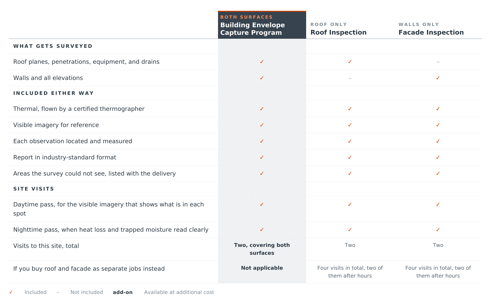
Thermal is a method, not a product. What you actually buy depends on what needs looking at. All three of these include thermal, because on a building envelope there is no version of this work without it.
The visit count is the whole argument for doing both at once. Every thermal survey needs a day pass and a night pass. Run the roof and the facade as separate jobs and that is four trips, two of them after hours. Run them together and it is two, because both surfaces get captured on the same passes.
Thermal work that is not a building envelope
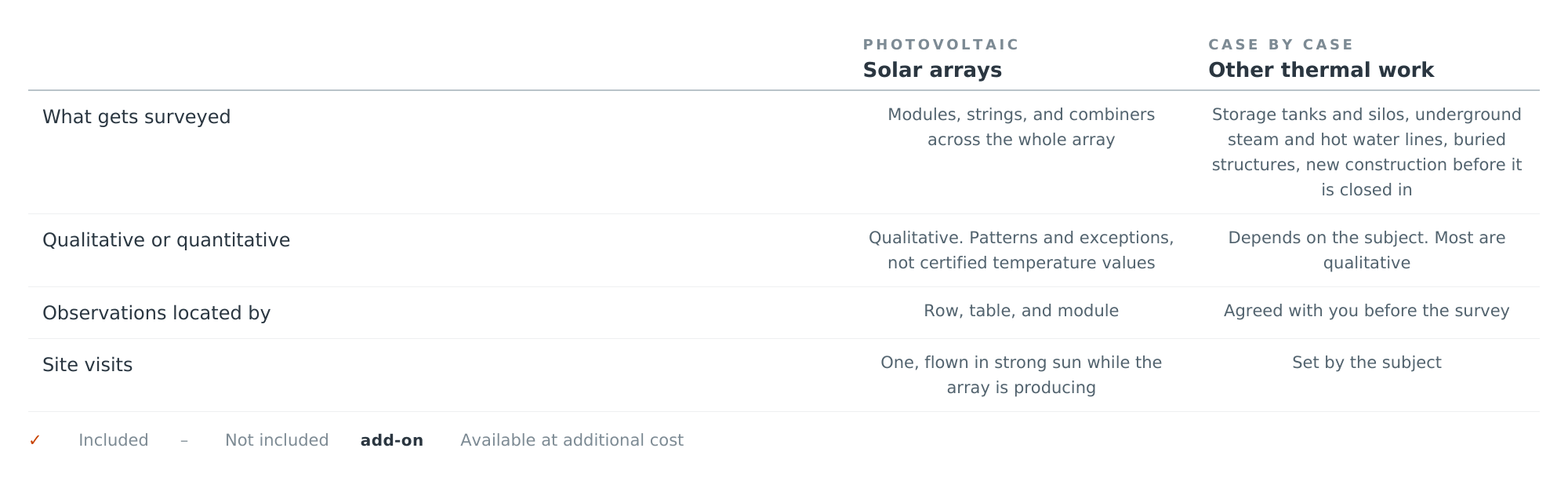
These are different jobs with different rules, so they are not part of the comparison above.
Neither of these has a page of its own. Tell us the subject and we will tell you plainly whether it is work we take, what it would involve, and who else would need to be on it.
Working with Your Team
We work alongside your project team. Engineers, architects, surveyors, contractors, and construction managers all get better information to work from, and nothing we deliver takes the place of what they do.
We measure. Your engineer of record, architect, and surveyor interpret. Our deliverables are built to go straight to the people already responsible for the design and the compliance calls.
The test for anything we write: could someone go up there with a tape and check it? If yes, it is ours. If it requires judgment, it is theirs.
Bring your own engineer, or we can introduce you to one
Most projects already have a structural engineer, envelope consultant, or architect in that seat, and our deliverables are built to land on their desk in a format they can work from the day they get it. When that seat is empty, we can put you in touch with firms we work with regularly who already know how to read what we produce. They engage with you directly and we take no fee or markup on their work. We stay on the measurement and they stay on the interpretation, which is what keeps both of them worth anything.
Limitations of use
Deliverables are aerial and terrestrial measurement products. They are not a boundary survey, not a topographic survey certified by a licensed land surveyor, and are not intended for establishing property lines, easements, or legal descriptions.
Accuracy is stated per deliverable. Where results will be used for design, permitting, regulatory submission, or determination of contractual compliance, they should be reviewed by your licensed surveyor or engineer of record.
Observations are those identified within the area captured, on the date captured, under the conditions recorded. Areas not visible to the capture are listed with each delivery.
DronePoint provides construction progress monitoring for surveyors, engineers, contractors, and property owners across New York, Pennsylvania, Ohio, and New England. Our capture work is processed in-house by Professional Drafting Service, the drafting firm behind DronePoint since 19887 – so what you receive is a finished, usable deliverable rather than a raw data dump you have to hire someone else to clean up.
Deliverables are provided in the formats and coordinate system your project requires.
Tell us about your site and we’ll come back with a scope and a price.
Call 716-447-9698 or request a quote.