Roof Inspection
What is on the roof, what shape it is in, and how much of it there is.
You need to budget a replacement, support a claim, or find out why it is leaking. A walk tells you a great deal, but only about the parts you can safely get to and only about what shows on the surface.
Thermal and visible imagery of every plane, flown together, with the area measured and every observation located.
One survey serves several decisions. The owner gets a defensible number for the capital request. The facility team knows which areas to watch. The roofing contractor bids against a measured area rather than a walk-around estimate. The insurer or the envelope consultant gets a dated record of what the roof looked like on a specific day.
What We Can Tell You
What the capture lets us report, measured rather than estimated.
Area And Geometry
Measured area of each roof plane, and of the roof as a whole
Location and count of penetrations, curbs, equipment, and drains
Slope and drainage direction across each plane
Conditions Observed
Where water stands after rain, and the measured extent of each area
Where thermal patterns differ from the surface around them, and the measured extent of each
Surface conditions visible from above, described as observed and located to a plane
Change Over Time
What changed since a previous survey of the same roof
How It Works
We fly the roof and produce a located, measured picture of where the anomalies are. Then we walk it with a handheld thermal imager and look at those areas close up. Doing it in that order makes the walk targeted instead of exploratory, and anything that cannot be reached safely on foot, a steep plane, a fragile deck, an area boxed in behind equipment, is already covered by the aerial pass.
Aerial first, then the walk
Everything else is measured and located on it, so an observation is tied to a position on the roof rather than to a photograph someone has to find again.
A roof-plane orthomosaic is the base
Thermal is in every version of this
A visual survey finds what is visible. On a low-slope roof the thing that matters most is often wet insulation under an intact membrane, which is invisible from above and reads clearly on thermal.
The thermal is flown at night, once the roof has shed its solar gain and trapped moisture reads most clearly. The daytime visit is what produces the visible imagery, because a thermal pattern means very little until you can see what is in that spot, and nothing photographs in the dark.
Two visits, day and night
Nothing we do cuts, probes, or opens the assembly. Verifying what an anomaly actually is takes hands-on testing that does: a core sample through the membrane, a moisture meter reading, lifting a section to see what is under it. We do not perform that testing and we do not substitute for it. We coordinate with the people who do, including your roofer and your building maintenance team, and the survey is what tells them where to test.
The method, its conditions, and its limits are covered in full on the Thermal Inspection page.
Our work is non-contact and non-invasive
Packages
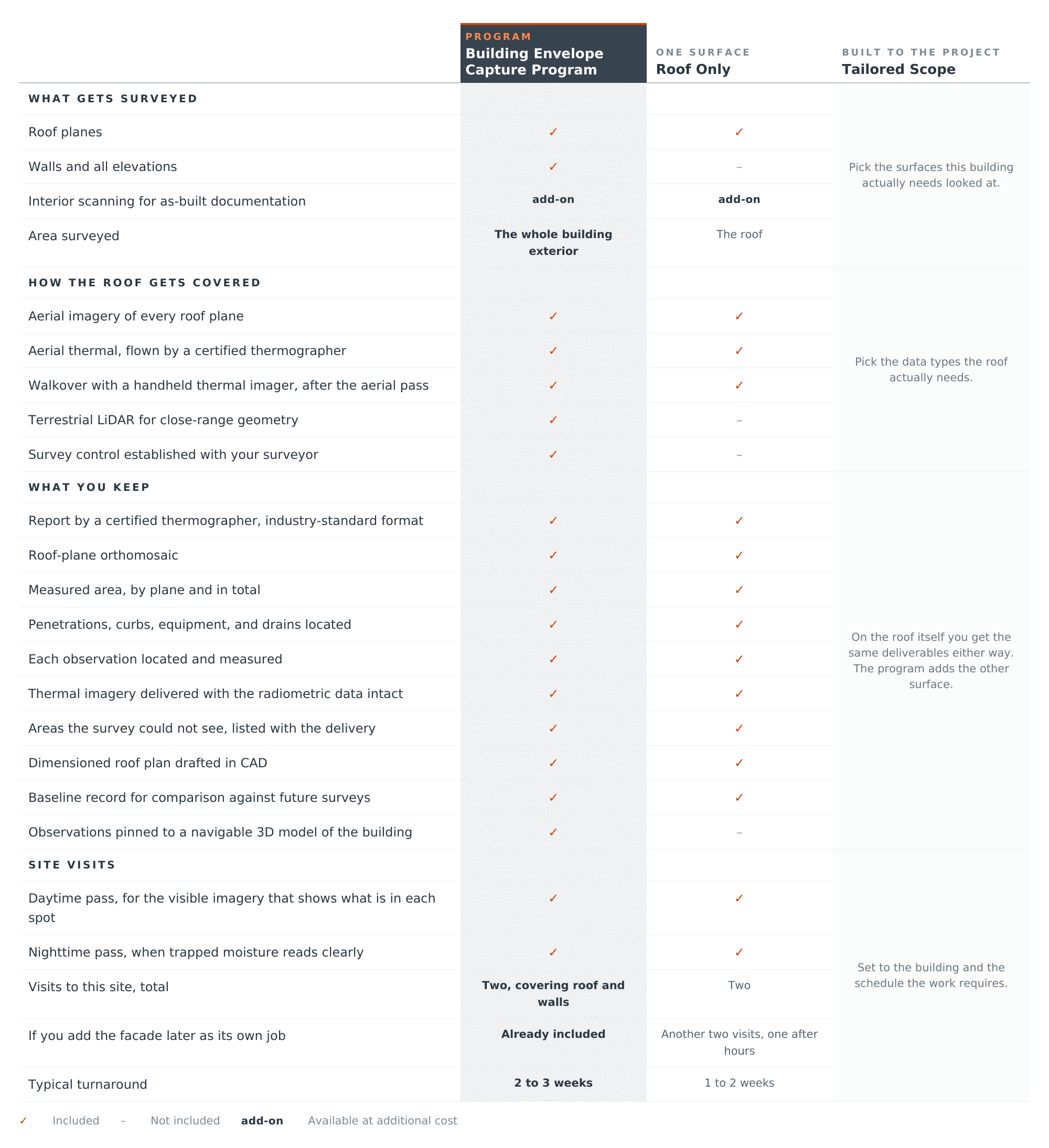
Compare what each one includes.
Why thermal is not optional on a roof
A visual survey finds what is visible. Split seams, open laps, punctures, failed flashing, standing water, debris in a drain. Those matter and we document all of them.
The condition that drives most replacement decisions is not visible. Wet insulation under a membrane that still looks fine from above holds heat differently than dry insulation around it, which is exactly what thermal reads. A roof can photograph well and still be saturated across a third of its area.
That is why thermal is in both columns rather than sold as an upgrade. A roof survey without it answers a narrower question than the one you are asking.
What it does not do is tell you what the anomaly is. A warm area is a place to core, not a conclusion. Verification takes invasive testing that we do not perform, and the call belongs to your roofing contractor or envelope consultant. The survey is built to hand them a short list of located, measured places to test instead of a roof to search.
Why Most Clients Take the Program
The roof meets the wall, and this is where the water gets in
Parapets, copings, counterflashing, and roof-to-wall transitions cause more envelope failures than either surface does on its own. Survey only the roof and you document one side of that junction. Survey only the walls and you document the other. Captured together it is one continuous surface, which is the only way to follow a problem across it.
The second surface costs a fraction of the first
Thermal needs a night pass, and a roof survey already includes one. Booked separately, the same coverage is four mobilizations, two of them after hours, because each surface pays for its own day visit and its own night visit. Booked together it is two, because the facade rides along on passes the roof already requires. You are paying for the second surface, not for a second job.
One record, one date, one set of conditions
Two separate engagements produce two reports from two different days under two different sets of weather, which nobody can reliably read against each other. One engagement gives you the building as it stood on a single date.
One model, not two partial ones
Roof and walls registered to the same control means an observation on a parapet and an observation on the wall beneath it sit in the same coordinate space, in the same model, and can be measured against each other.
The record outlives the report
The report answers today's question. The dataset answers every future one, including comparison, design, renovation, and claims.
Tailored Scope
Tailored Scope starts at the single-service level and goes up. Different coverage, different deliverables, different cadence.
Frequency
Once, at milestones, or on a set cadence.
Extent
Which areas, which elevations, which portion of the site.
Accuracy
Whether survey control and independent verification are required.
Format
Raw data, registered data, or drafted output in your CAD environment.
Combination
Any services from any package, assembled for the project.
Working with Your Team
We work alongside your project team. Engineers, architects, surveyors, contractors, and construction managers all get better information to work from, and nothing we deliver takes the place of what they do.
We measure. Your engineer of record, architect, and surveyor interpret. Our deliverables are built to go straight to the people already responsible for the design and the compliance calls.
The test for anything we write: could someone go up there with a tape and check it? If yes, it is ours. If it requires judgment, it is theirs.
Bring your own engineer, or we can introduce you to one
Most projects already have a structural engineer, envelope consultant, or architect in that seat, and our deliverables are built to land on their desk in a format they can work from the day they get it. When that seat is empty, we can put you in touch with firms we work with regularly who already know how to read what we produce. They engage with you directly and we take no fee or markup on their work. We stay on the measurement and they stay on the interpretation, which is what keeps both of them worth anything.
Limitations of use
Deliverables are aerial and terrestrial measurement products. They are not a boundary survey, not a topographic survey certified by a licensed land surveyor, and are not intended for establishing property lines, easements, or legal descriptions.
Accuracy is stated per deliverable. Where results will be used for design, permitting, regulatory submission, or determination of contractual compliance, they should be reviewed by your licensed surveyor or engineer of record.
Observations are those identified within the area captured, on the date captured, under the conditions recorded. Areas not visible to the capture are listed with each delivery.
DronePoint provides construction progress monitoring for surveyors, engineers, contractors, and property owners across New York, Pennsylvania, Ohio, and New England. Our capture work is processed in-house by Professional Drafting Service, the drafting firm behind DronePoint since 19887 – so what you receive is a finished, usable deliverable rather than a raw data dump you have to hire someone else to clean up.
Deliverables are provided in the formats and coordinate system your project requires.
Tell us about your site and we’ll come back with a scope and a price.
Call 716-447-9698 or request a quote.