
Facade Inspection
The exterior wall, recorded and measured, without mobilizing access.
Something came off the building, an ordinance is due, or you need evidence before anyone will fund the repair. Getting a person within arm's reach of the wall means scaffold, a swing stage, or rope access, and that decision has to be made before anyone knows how much of the wall is actually a problem.
Every elevation at high resolution, with observations located and measured, each one pinned to its position on a model of the building you can navigate.
One survey serves several decisions. The owner gets evidence for the capital request. The envelope engineer gets located, measured starting points and a defined area to scope a hands-on survey against. The contractor bids repair against a real quantity. Counsel and the insurer get a dated record of the wall on a specific day.
What We Can Tell You
What the capture lets us report, measured rather than estimated.
Location And Measurement
The location of every observation by elevation, floor line, and bay.
Measured length, width, and area of anything visible on the wall
Movement And Pattern
Displacement, bow, and out-of-plane deviation measured from the captured geometry.
Where thermal patterns differ from the surface around them, and the measured extent of each, when thermal is included
Distribution And Change
Counts of similar observations across an elevation, and how they are distributed.
What changed between two captures of the same elevation
How It Works
No scaffold, no swing stage, no rope crew, and no closure beyond what the flight itself requires. The whole wall is documented in as little as a single day, against the weeks it takes to stand up access.
Every elevation, no access mobilized
Each one is pinned to its actual position on a navigable model of the facade. You click the location and get the observation, its measurement, and the imagery it came from, instead of trying to work out which elevation a photograph belongs to.
Observations live on the building, not in a photo album
We record what the capture shows, measured and located, and name a condition by its appearance rather than by what caused it. A linear surface defect consistent in appearance with cracking is a measurement. Saying why it is there is a professional opinion, and that belongs to your engineer or architect.
Described as observed
On questions of energy and moisture it is the most useful thing on a facade survey, reading heat loss through the assembly and water held behind a cladding that still looks sound. On questions of structure and safety, which is most ordinance work and most post-failure work, the visible and geometric record does the job and thermal adds a night visit you do not need. We will tell you which of those your building is before you pay for it.
Thermal is available and it is not always the right spend
Thermal means a second visit
It is flown at night, once the building has shed its solar gain and heat loss and trapped moisture read most clearly. The daytime visit produces the visible imagery, because a thermal pattern means very little until you can see what is in that spot, and nothing photographs in the dark. Without thermal, a facade survey is one daytime visit.
Nothing we do touches, sounds, or opens the wall. Verifying what a condition actually is takes hands-on material testing that does: sounding masonry with a hammer to find hollow or delaminated areas, probing mortar joints, pulling a unit, a borescope behind the cladding, moisture readings. We do not perform that testing and we do not substitute for it. We coordinate with the people who do, and the survey is what tells them where to test.
The method, its conditions, and its limits are covered in full on the Thermal Inspection page.
Our work is non-contact and non-invasive
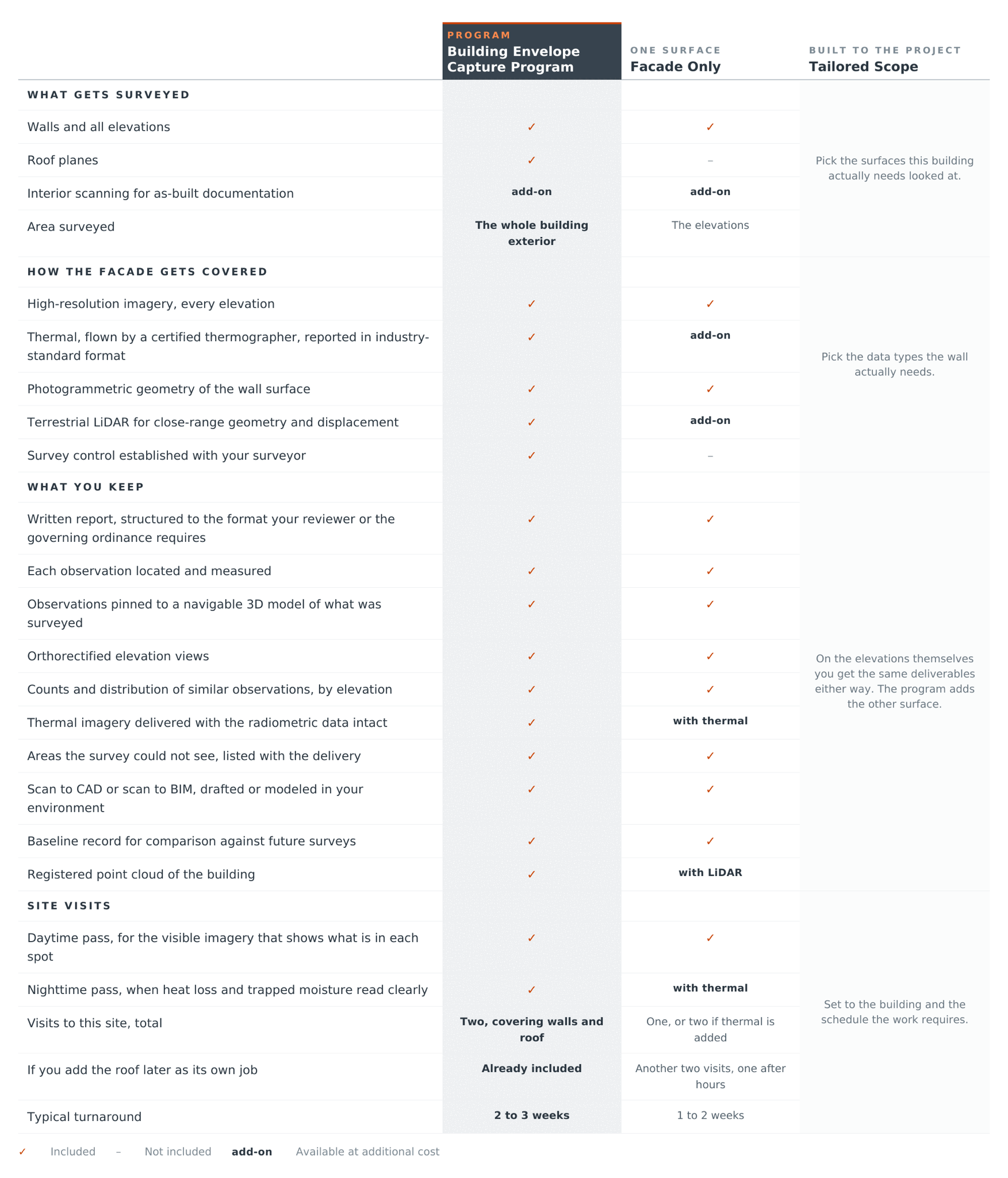
The survey bounds the problem. It does not replace the hands-on work.
Close inspection of a facade means getting within arm's reach of it, and that takes scaffold, a swing stage, or a rope crew. Standing that up costs real money and takes weeks, and the scope has to be decided before anyone knows how much of the wall is actually involved.
That is the problem the survey solves. The whole building gets documented in days, every elevation, with observations located and measured. Your engineer then scopes hands-on access against a defined area rather than against a guess, and you fund it against evidence rather than against an estimate.
What the survey will not do is sound a wall, pull a unit, or tell you why a condition is there. Those remain the engineer's work and the contractor's, and this is built to make both of them cheaper and better aimed.
Operating note. Flights are run under Part 107. Flight over people is restricted, so the area beneath the flight path may need to be controlled while we work. We plan that with you rather than discovering it on the day.
Why Most Clients Take the Program
The roof meets the wall, and that is where the water gets in
Parapets, copings, counterflashing, and roof-to-wall transitions cause more envelope failures than either surface does on its own. Survey only the roof and you document one side of that junction. Survey only the walls and you document the other. Captured together it is one continuous surface, which is the only way to follow a problem across it.
The second surface costs a fraction of the first
Thermal needs a night pass, and a roof survey already includes one. Booked separately, the same coverage is four mobilizations, two of them after hours, because each surface pays for its own day visit and its own night visit. Booked together it is two, because the facade rides along on passes the roof already requires. You are paying for the second surface, not for a second job.
One record, one date, one set of conditions
Two separate engagements produce two reports from two different days under two different sets of weather, which nobody can reliably read against each other. One engagement gives you the building as it stood on a single date.
One model, not two partial ones
Roof and walls registered to the same control means an observation on a parapet and an observation on the wall beneath it sit in the same coordinate space, in the same model, and can be measured against each other.
The record outlives the report
The report answers today's question. The dataset answers every future one, including comparison, design, renovation, and claims.
Tailored Scope
Tailored Scope starts at the single-service level and goes up. Different coverage, different deliverables, different cadence.
Frequency
Once, at milestones, or on a set cadence.
Extent
Which areas, which elevations, which portion of the site.
Accuracy
Whether survey control and independent verification are required.
Format
Raw data, registered data, or drafted output in your CAD environment.
Combination
Any services from any package, assembled for the project.
Working with Your Team
We work alongside your project team. Engineers, architects, surveyors, contractors, and construction managers all get better information to work from, and nothing we deliver takes the place of what they do.
We measure. Your engineer of record, architect, and surveyor interpret. Our deliverables are built to go straight to the people already responsible for the design and the compliance calls.
The test for anything we write: could someone go up there with a tape and check it? If yes, it is ours. If it requires judgment, it is theirs.
Bring your own engineer, or we can introduce you to one
Most projects already have a structural engineer, envelope consultant, or architect in that seat, and our deliverables are built to land on their desk in a format they can work from the day they get it. When that seat is empty, we can put you in touch with firms we work with regularly who already know how to read what we produce. They engage with you directly and we take no fee or markup on their work. We stay on the measurement and they stay on the interpretation, which is what keeps both of them worth anything.
Limitations of use
Deliverables are aerial and terrestrial measurement products. They are not a boundary survey, not a topographic survey certified by a licensed land surveyor, and are not intended for establishing property lines, easements, or legal descriptions.
Accuracy is stated per deliverable. Where results will be used for design, permitting, regulatory submission, or determination of contractual compliance, they should be reviewed by your licensed surveyor or engineer of record.
Observations are those identified within the area captured, on the date captured, under the conditions recorded. Areas not visible to the capture are listed with each delivery.
DronePoint provides construction progress monitoring for surveyors, engineers, contractors, and property owners across New York, Pennsylvania, Ohio, and New England. Our capture work is processed in-house by Professional Drafting Service, the drafting firm behind DronePoint since 19887 – so what you receive is a finished, usable deliverable rather than a raw data dump you have to hire someone else to clean up.
Deliverables are provided in the formats and coordinate system your project requires.
Tell us about your site and we’ll come back with a scope and a price.
Call 716-447-9698 or request a quote.