
Existing Conditions Documentation
What is actually there, measured, and drawn the way your team draws.
The drawings are forty years old, or they are a scan of a copy of a scan, or there are none. The building has been modified half a dozen times since and none of it was recorded. Design against that record and you discover the real building during construction, when a change order is the only way left to fix it.
We scan the building, inside and out, and deliver measured drawings and models in your environment, built from what is standing rather than from what was drawn.
One scan serves several decisions. The architect designs against real geometry. The mechanical engineer routes through space that exists. The contractor bids against actual quantities instead of allowances. The owner ends up with a record of the building that outlasts the project that paid for it.
What We Can Tell You
What the capture lets us report, measured rather than estimated.
Dimensions And Geometry
Room by room dimensions, floor to floor heights, and overall building geometry
Size and position of every door, window, and opening
Shaft, stair, and elevator geometry
Structure And Systems
Where the structure actually sits, with columns, beams, and bearing walls located as built
Clear height available above the ceiling, and what is already occupying it
Routing and position of exposed mechanical, electrical, and plumbing
Tolerance And Deviation
How far walls run out of plumb and floors out of level, measured rather than estimated
Where the building as it stands differs from the record drawings you already have
How It Works
A scanner on a tripod moves through the building, and every setup is registered into one point cloud. Every dimension on the drawing traces back to a measurement, not to a tape read off a ladder and transcribed into a notebook.
Measured, not field sketched
Each level is tied to the ones above and below it and to the exterior. A shaft lines up through the building, a column lands on the column beneath it, and a section cut anywhere produces geometry that agrees with itself.
One coordinate system, so the floors stack
Your layers, your blocks, your title block, your Revit template and families. Our drafting arm has been producing construction documents since 1987, which is the part most scanning firms subcontract or skip. A model delivered in somebody else's standards is a model your team rebuilds.
Drafted and modeled in your environment
Level of detail is agreed before we start
Modeling everything costs more than modeling what you need. We settle up front what gets modeled, what gets drawn in two dimensions, and what stays in the cloud for reference, so you are not paying to model a ceiling grid nobody is going to touch.
We work around the building
Occupied floors, operating hours, secure areas, after hours access. Scanning is quiet, needs no power, and leaves nothing behind.
Most of this work needs no drone at all. Where a roof or an upper exterior matters to the as-built and cannot be reached from the ground, we add a flight to close that gap, and we tell you whether it is needed before it is on the invoice.
Aerial only where the ground cannot see
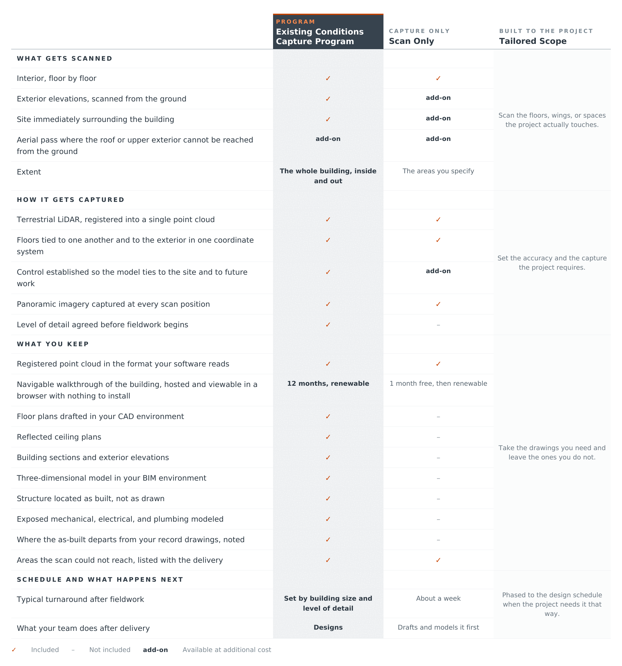
Packages
Compare what each one includes.
What This Does Not Cover
This records geometry, not condition
We document where everything is and how big it is. We do not assess what shape it is in. If the question is whether the roof or the walls are failing, that is a building envelope survey and it is a different scope, on a different page, with a different deliverable.
We scan what is visible
A scanner records surfaces, so what sits behind a finish, above a hard ceiling, or inside a chase stays unrecorded. Selective demolition and probing reveal those, and we can come back and scan once they are open. Record drawings and your own judgment fill the rest.
Access decides coverage
A locked room is not in the model. Every space that needs to be documented has to be open to us on the day we are there, which sounds obvious and is the single most common cause of a return trip. We work the list out with you before we mobilize.
A model is a representation
Accuracy is stated with the delivery and it is tight, but a modeled wall is a surface fit to measured points, not the wall itself. Where a dimension is critical to fabrication, it should be verified in the field against the element being fabricated to.
Why Most Clients Take the Program
A point cloud is not a drawing
You cannot put one in a title block, issue it to a consultant, or submit it for permit. Somebody has to turn it into drawings and a model, and that somebody is either your staff at your billable rate or ours at ours. Buying the scan alone does not avoid that work, it just moves it onto your desk.
The scanning is the short part
Fieldwork on a typical building runs a day or two. The drafting and modeling is where the weeks go. Pricing the two separately makes the scan look like the project when it is the smaller half of it.
We draft the way you draft
Your layers, your standards, your template, your families. This is a drafting firm that scans, not a scanning firm that outsources the drawings, and the difference shows up in whether your team can start working in the file or has to rebuild it first.
Scanning twice costs more than scanning once
Teams that capture only the area they think the project touches come back when the project grows, and the second visit is a second mobilization, a second registration, and a seam between two datasets captured months apart under different conditions. Capturing the whole building the first time is the cheapest version of that.
The record outlives the project
The drawings answer this renovation. The model and the cloud answer the next one, the fit-out after that, the equipment that has to get through the door, and the facilities questions nobody has asked yet.
Tailored Scope
Tailored Scope starts at the single-service level and goes up. Different coverage, different deliverables, different cadence.
Frequency
Once, at milestones, or on a set cadence.
Extent
Which areas, which elevations, which portion of the site.
Accuracy
Whether survey control and independent verification are required.
Format
Raw data, registered data, or drafted output in your CAD environment.
Combination
Any services from any package, assembled for the project.
Working with Your Team
We work alongside your project team. Engineers, architects, surveyors, contractors, and construction managers all get better information to work from, and nothing we deliver takes the place of what they do.
We measure. Your engineer of record, architect, and surveyor interpret. Our deliverables are built to go straight to the people already responsible for the design and the compliance calls.
The test for anything we write: could someone go up there with a tape and check it? If yes, it is ours. If it requires judgment, it is theirs.
Bring your own engineer, or we can introduce you to one
Most projects already have a structural engineer, envelope consultant, or architect in that seat, and our deliverables are built to land on their desk in a format they can work from the day they get it. When that seat is empty, we can put you in touch with firms we work with regularly who already know how to read what we produce. They engage with you directly and we take no fee or markup on their work. We stay on the measurement and they stay on the interpretation, which is what keeps both of them worth anything.
Limitations of use
Deliverables are aerial and terrestrial measurement products. They are not a boundary survey, not a topographic survey certified by a licensed land surveyor, and are not intended for establishing property lines, easements, or legal descriptions.
Accuracy is stated per deliverable. Where results will be used for design, permitting, regulatory submission, or determination of contractual compliance, they should be reviewed by your licensed surveyor or engineer of record.
Observations are those identified within the area captured, on the date captured, under the conditions recorded. Areas not visible to the capture are listed with each delivery.
DronePoint provides construction progress monitoring for surveyors, engineers, contractors, and property owners across New York, Pennsylvania, Ohio, and New England. Our capture work is processed in-house by Professional Drafting Service, the drafting firm behind DronePoint since 19887 – so what you receive is a finished, usable deliverable rather than a raw data dump you have to hire someone else to clean up.
Deliverables are provided in the formats and coordinate system your project requires.
Tell us about your site and we’ll come back with a scope and a price.
Call 716-447-9698 or request a quote.